دنیای زبان انگلیسی ( بهروزپور )
لغات و اصطلاح .داستان کوتاه . شعر.جوک .ضرب المثل.اشپزی.رمان. نمایشنامه.متن دوزبانهدنیای زبان انگلیسی ( بهروزپور )
لغات و اصطلاح .داستان کوتاه . شعر.جوک .ضرب المثل.اشپزی.رمان. نمایشنامه.متن دوزبانهMasouleh ماسوله
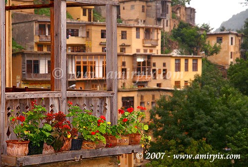
Masouleh (Persian: ماسوله, Māsūleh; also known as Masuleh) is a village in the Gilan Province of Iran. Historical names for the village include Māsalar and Khortāb. It was founded in the 10th century AD, and its current population is estimated to be around 800 people.
Geography, History and climate
Masouleh is approximately 60 km southwest of Rasht and 32 km west of Fuman. The village is 1 050 meters above sea level in the Alborz (or Elburz) mountain range, near the southern coast of the Caspian Sea. The village itself has a difference in elevation of 100 meters.
The first village of Masouleh is approximately established around 1006 AD, 6 km Northwest of the current village, and it is called Old-Masouleh (Kohneh Masouleh in Persian). People moved from Old-Masouleh to the current village because of Pestilence and neighbor attacks. Some of old families do have a written Ancestral tree as old as one hundred years.
Masouheh-Rood-Khan is the river passing through the village with a water fall 200m away from the village. Many other springs are found around Masouleh.
Masouleh is also surrounded by forest from valley to mount.
Fog is the predominate weather feature of Masouleh. Although it has been written that the community was established around 10 AD, the province of Gilan has a long history.

شهرهای دیدنی ایران : Geography and Nature
Geography and Nature
of Iran
Covering an area of 1,648,000 square kilometers, the Islamic Republic of Iran is located in southwestern Asia. The Caspian Sea, Turkmenistan, Azerbaijan and Armenia in the north; Afqanistan and Pakistan in the east; Turkey and Iraq in the west surround the country. On the south Iran borders the Persian Gulf and the Sea of Oman. Total terrestrial borders of the country are 5,170 km. and total water borders are 2,510 km.
Caspian Sea, Gilan
Iran is situated at the heart of the Middle East and, as a bridge, links the Caspian Sea, the largest land-locked body of water in the world, to the Persian Gulf. It is also a crossroad between the East and the West. Thus, historically, Iran has been in the juncture of cultural, intellectual and political manifestations of both the East and the West, while preserving it"s unique identity.
Unique landscapes such as limpid water springs, pomegranate orchards, pistachio gardens, rows of lombardy poplars, decampment of nomads in different seasons, stelliferous nights, rocky mountains, endless high and low lands, extinct snow-clad volcanoes, dense forests of the Alborz Mountain Range, and coastlines of the Caspian Sea, the Persian Gulf and the Sea of Oman are all eye-catching and memorable.
Abumoosa Island
Iran"s landscapes vary remarkably at different seasons. They are at times full of stone and sand, at times full of floodwater, sometimes covered by snow or by lush vegetation. Iranian artists have portrayed Iran"s nature as a sign of diversity and charm in their different and diverse artistic works. Iranians also have traditionally valued Water as a symbol of life and development. Innumerable permanent streams can be seen flowing in meadows, gardens, orchards, homes, mosques and sacred places irrigating trees.Nature and it"s diversity in Iran are valuable parameters for development of the tourism industry. In total, it is estimated that 19 million hectares of terrestrial land are covered by orchards, gardens and farmlands; 10 million hectares are plain and pastures; 19 million hectares are forests; and the remaining include barren lands, desert, and mountains.
ادامه مطلب ...
A short history of high buildings in Iran

Introduction
The idea of high buildings can be traced to many centuries ago when monarchs built, fortresses on elevated hill-tops, from where they could keep the surrounding areas under surveillance. Such a building was also useful for the deference of the city.
Ancient fortresses overlooking a vast expanse of land are historical examples that are found in abundance in most countries.
High Buildings in Pre-Islamic Period
One of the most glamorous citadels still extant in the south-west of present-day Iran (Province of Khuzestan) is Ziggurat ‘Chogha Zanbil’ which was built by the Elamite Empire in 1250 BCE. This temple was built in the shape of a stepped pyramid, originally having five stories. The remains of the building in its present shape have a high of 25 meters though it is believed that the building was initially 50 meters high.
During the Median Empire which followed the rule of Elamites residential houses were often built in the low lands whereas the uplands were designated for the royal palaces.
ادامه مطلب ...
زیبایی های محلات
Natural Attractions of Mahallat

Deep within the arid areas of west-central Iran is the beautiful city of Mahallat located amid mountains and enjoying a pleasant weather. It shines like a piece of paradise in view of the numerous springs and the existence of ever-green and natural sceneries.
Foreign tourists also visit Mahallat because of its flowers, orchards and gardens.
A sprawling green park known as Sarcheshmeh in the northern part of Mahallat provides a beautiful image to the whole city. The existence of a spring of sweet water adds to the spectacular beauty of this park.

Everywhere in Mahallat are greenhouses displaying a variety of beautiful flowers that amaze the eyes of visitors. Some of the greenhouses are specifically allocated to the cultivation of only one type of flower. Every year in September Mahallat holds a grand flower exhibition that attracts people from throughout Iran and abroad.
Some five million flowers are produced in Mahallat annually and exported to the domestic and foreign markets.
According to local officials, the city earns $17 million through export of flowers, and produces one-fourth of Iran’s decorative plants and flowers.
ادامه مطلب ...
Kish Island
Kish Island

Kish Island is a resort island lapped by the sheltered waters of coral-edged lagoons, home for too many of the world"s spices of reef fish. Snorkeling in the Kish Island is amongst the best in the world, while scuba diving offers an even more spectacular insight of life beneath the waters.
Kish lies like a pearl across the turquoise waters of the Persian Gulf and is a heaven of Peace and tranquility fringed by sandy beaches and coral reefs vivid with colorful fish.
A variety of other water sports are also available. Jet-skiing, sailing, fishing, parasailing, Reef walking, coral viewing, boating and water skiing are just a few popular ways to Spend the time and enjoy yourself during your visit to the Island.
Kish Island has a calm and beautiful coast. Kish soil is made of coral with a silvery Color dazzlingly shining under the sunlight. The sea water in Kish Island is bright And clear in a way that the bottom of the sea can be easily seen from a very far Distance.

Kish coast is one of the least dangerous coasts in the world.
These are just few reasons that have turned Kish Island into a popular holiday Destination in the region. All together, Kish Island offers a stunning variety of cultures, Scenery, sports, duty-free shopping and entertainment.
ادامه مطلب ...
mashhad
Mashhad (Persian: مشهد from Arabic: مشهد, ‹Mašhad›, literally the place of martyrdom)[3][4] is the second largest city in Iran and one of the holiest cities in the Shia Muslim world. It is also the only major Iranian city with an Arabic name. It is located 850 kilometres (530 mi) east of Tehran, at the center of the Razavi Khorasan Province close to the borders of Afghanistan and Turkmenistan. Its population was 2,427,316 at the 2006 population census.[1]
Now Mashhad is notably known as the resting place of the Imam Reza. A shrine was later built there to commemorate the Imam, which in turn gave rise to increasing demographic development.
Mashhad is also known as the city of Ferdowsi, the eminent Iranian poet of Shahnameh, which is considered to be the national epic of Iran.
ادامه مطلب ...
tabriz
Tabriz (Persian/Azerbaijani:تبریز) is the most populated city in Iranian Azerbaijan, it is fourth largest city in Iran and the capital of East Azerbaijan Province. Situated at an altitude of 1,350 meters at the junction of the Quri River and Aji River, it was the second largest city in Iran until the late 1960s, one of its former capitals, and residence of the crown prince under the Qajar dynasty. The city has proven extremely influential in the country’s recent history. Tabriz is located in a valley to the north of the long ridge of the volcanic cone of Sahand, south of the Eynali mountain. The valley opens out into a plain that slopes gently down to the northern end of Lake Urmia, 60 km to the west. With cold winters and temperate summers the city is considered a summer resort.
The estimated population of the city is around 1,400,000[1] based on results of the Iranian census bureau. Tabriz is the fourth most populated city in Iran after Tehran, Mashhad, and Esfahan, while also being a major Iranian heavy industrial and manufacturing center. Some of these industries include automobile, machine tools, oil and petrochemical and cement production.[2]
With a rich history, Tabriz contains many historical monuments, which repeated devastating earthquakes have substantially damaged. Monuments date back to the Ilkhanid, Safavid, and Qajar periods[3][4][5], with the large Tabriz Historic Bazaar Complex being named as a World Heritage Site in 2010.
ادامه مطلب ...
tabriz
Tabriz (Persian/Azerbaijani:تبریز) is the most populated city in Iranian Azerbaijan, it is fourth largest city in Iran and the capital of East Azerbaijan Province. Situated at an altitude of 1,350 meters at the junction of the Quri River and Aji River, it was the second largest city in Iran until the late 1960s, one of its former capitals, and residence of the crown prince under the Qajar dynasty. The city has proven extremely influential in the country’s recent history. Tabriz is located in a valley to the north of the long ridge of the volcanic cone of Sahand, south of the Eynali mountain. The valley opens out into a plain that slopes gently down to the northern end of Lake Urmia, 60 km to the west. With cold winters and temperate summers the city is considered a summer resort.
The estimated population of the city is around 1,400,000[1] based on results of the Iranian census bureau. Tabriz is the fourth most populated city in Iran after Tehran, Mashhad, and Esfahan, while also being a major Iranian heavy industrial and manufacturing center. Some of these industries include automobile, machine tools, oil and petrochemical and cement production.[2]
With a rich history, Tabriz contains many historical monuments, which repeated devastating earthquakes have substantially damaged. Monuments date back to the Ilkhanid, Safavid, and Qajar periods[3][4][5], with the large Tabriz Historic Bazaar Complex being named as a World Heritage Site in 2010
ادامه مطلب ...